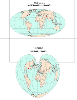
Distances between Washington D.C. and Kabul
Gall stereographic: 7,123.7 miles
Mercator: 10,122.7 miles
Mollweide: 7,900 miles
Bonne: 6,835 miles
Sinusoidal: 8,092 miles
Plate carre 10,112 miles
Gall stereographic: 7,123.7 miles
Mercator: 10,122.7 miles
Mollweide: 7,900 miles
Bonne: 6,835 miles
Sinusoidal: 8,092 miles
Plate carre 10,112 miles
A map projection is a way of interpreting the three dimensional surface of the Earth onto a two dimensional plane. This is useful because it is not often possible to view the Earth in 3D. Unfortunately, though, all projections have to sacrifice accuracy in area, distance, or shape. Projections can be classified according to what qualities they preserve, and each has specific advantages and disadvantages. Clearly, different projections can give startlingly varied representations of Earth's landmasses.
Mercator and Gall stereographic projections are examples of conformal projections. Conformal projections are characterized by parallels and meridians that intersect at right angles. The advantage of this type of projection is that local shapes and angles are preserved, but area can be variant. For example, on the Mercator, area near the poles is lengthened dramatically, which gives the impression that Greenland and Antarctica are extremely large.
The Mollweide and Bonne projections are examples of equal area projections, which maintain a proportional relationship to areas on the Earth the represent. These maps thus give a good idea of how large landmasses are in relation to one another, but are not so useful for determining how far apart things really are. The last set of maps, the Sinusoidal and Plate carre projections, are equidistant maps. These projections maintain uniform distance from the center of the map to any other place on the map. This is very useful when trying to determine distance from a particular location.
Although one usually thinks of distance as absolute, it is clear from the examples above that attributes like it can be warped depending on the map. Because angles, shapes, and areas can vary so much, one must carefully consider what projection is best for the purpose of the map. However, when the scale is very large, this becomes less important, because the distortion is so small.


No comments:
Post a Comment