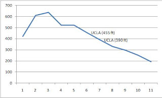
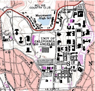
2. The adjacent quadrangles are Canoga Park, Van Nuys, Burbank, Topanga, Hollywood, Venice, and Inglewood.
3. The map was first produced in 1966 (and most recently revised in 1999).
4. The datum used was the North American Datum of 1927 and 1983.
5. The scale is 1:24,000
6. a) 5 cm on the map = 1,200 m on the ground.
b) 5 in on the map = 1.894 mi on the ground.
c) 1 mi on the ground = 2.64 in on the map.
d) 3 km on the ground = 12.5 cm on the map
7. The counter interval is 20 ft.
8. a) the Public Affairs Building is at 34.07261 N and 118.43934 W / 34 degrees 4.3566' 21.396'' N and 118 degrees 26.3604' 21.624'' W
b)The tip of the Santa Monica pier is at 34.00743 N and 118.49992 W / 34 degrees .4458' 26.748" N and 118 29.9952 59.712 W
c) the Upper Franklin Canyon Reservoir is at 34.12042 N and 118.41016 W / 34 degrees 702252' 13.512" N and 118 degrees 24.6096' 36.576" W
9. a) the approximate elevation of Greystone Mansion is 560 ft / 170.69 m
b) Woodlawn Cemetary: 140 ft / 42.67 m
c) Crestwood Hills Park: 600 ft /182.88 m
10. The UTM zone is 11S.
11. The UTM coordinates for the lower left corner are around 3762950 and 0361500.
12. 250,000 square meters in each cell of UTM gridlines.
13.


14. The magnetic declination is 14 degrees east.
15. The stream flows south.
16.


No comments:
Post a Comment